This section illustrates how to manage the Viewer configurations in MapStore.
MapStore load its Viewer Configuration from the filesystem and the Map Configuration from GeoStore
GeoStore is not mandatory, the Map Configuration can be embedded in the Viewer Configuration
The Map Viewer configurations folder is in WEB-INFappstaticconfig
The webapp folder structure is:
/mapcomposer/
    -WEB-INF
        -app
            -static
                -config
                    -customPanelSample.js
                    -geonetwork.js
                    -mapStoreConfig.js
                    -markerEditor.js
                    -minimal.js
                    -queryConfig.js
                    -trainingConfig.js
                    -viewerConfig.js
Different configurations can be selected passing the config parameter set with the filename (without trailing ‘.js’) to the mapcomposer URL
When loading the Map Configuration from GeoStore it will override the one embedded in the Viewer Configuration
To get the Map Configuration from GeoStore the corresponding resource id must be bassed with the mapId parameter in the URL
A tipical configuration is a JSON formatted file with these properties:
The following steps will introduce to the configuration setup
Open the trainingConfig.js file and add the following snippet to the gsSources JSON object:
"google": {
        "ptype": "gxp_googlesource"
},
The resulting object should be:
"gsSources":{
        "geosolutions": {
                "ptype": "gxp_wmssource",
                "url": "http://localhost:8080/geoserver/wms",
                "title": "GeoSolutions GeoServer",
                "SRS": "EPSG:900913",
                "version":"1.1.1",
                "layersCachedExtent": [
                        -20037508.34,-20037508.34,
                        20037508.34,20037508.34
                ],
                "layerBaseParams":{
                        "FORMAT":"image/png8",
                        "TILED":true
                }
        },
        "osm": {
                "ptype": "gxp_osmsource"
        },
        "ol": {
                "ptype": "gxp_olsource"
        },
        "google": {
                "ptype": "gxp_googlesource"
        }
}
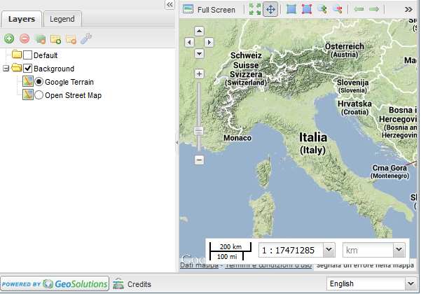
Add a Google background to the map adding a layer to the map
{
        "source": "google",
        "title": "Google Terrain",
        "name": "TERRAIN",
        "group": "background"
}
The resulting map object should be:
"map": {
        "projection": "EPSG:900913",
        "units": "m",
        "center": [1250000.000000, 5370000.000000],
        "zoom":5,
        "maxExtent": [
                -20037508.34, -20037508.34,
                20037508.34, 20037508.34
        ],
        "layers": [
                {
                        "source": "osm",
                        "title": "Open Street Map",
                        "name": "mapnik",
                        "group": "background"
                },{
                        "source": "google",
                        "title": "Google Terrain",
                        "name": "TERRAIN",
                        "group": "background"
                }
        ]
}
The Viewer will now show the Google layer in the map
To have an empty background insert the following code as a map layer
{
        "source": "ol",
        "title": "Empty Background",
        "group": "background",
        "fixed": true,
        "type": "OpenLayers.Layer",
        "visibility": false,
        "args": [
                "None", {"visibility": false}
        ]
}
In the customTools list add the following objects
{
        "actions": ["-"],
        "actionTarget": "paneltbar"
}, {
        "ptype": "gxp_geolocationmenu",
        "outputTarget": "paneltbar",
        "toggleGroup": "toolGroup",
        "index": 23
}
The first part tells MapStore to add a separator to the top toolbarThe second one adds the GeoLocation plugin to the same toolbar, specifing that should toggle with other toolGroup buttons and be placed in position “23”